Sim racers put a lot of time into making their cars and tracks look as realistic as possible. Unfortunately, many times the 3D assets used in sim racing are not up to par. 3D asset creation is a process that takes many man hours – especially if you want to achieve high-quality results.

Fortunately, there is an old technology that is gaining new popularity which can help reduce the amount of time needed to create stunning 3D assets: photogrammetry. And when I say old, I mean it—photogrammetry was first developed in 1849, and the principles behind it were developed by Leonardo DaVinci in 1490!
In this post, I will list the top 10 reasons why photogrammetry software is the best way to create high-quality 3D assets for sim racing. Let's dive in!
Photogrammetry is taking measurements from photographs in a process called structure from motion (SFM) to create accurate 3D data. This data can be used for a variety of purposes, such as creating detailed models of buildings or terrain.
The process of photogrammetry begins with the capture of images, which can be done using aerial photography methods or more specialized close-range photogrammetry techniques. Once the images have been captured, they are fed into photogrammetry software, which reconstructs the scene in three dimensions.

The resulting data is highly accurate and can be used to create detailed models or maps. Photogrammetry is an essential tool for anyone who needs to create accurate 3D data from the real world.
In recent years, photogrammetry has become an increasingly popular method for obtaining reliable information about physical objects.
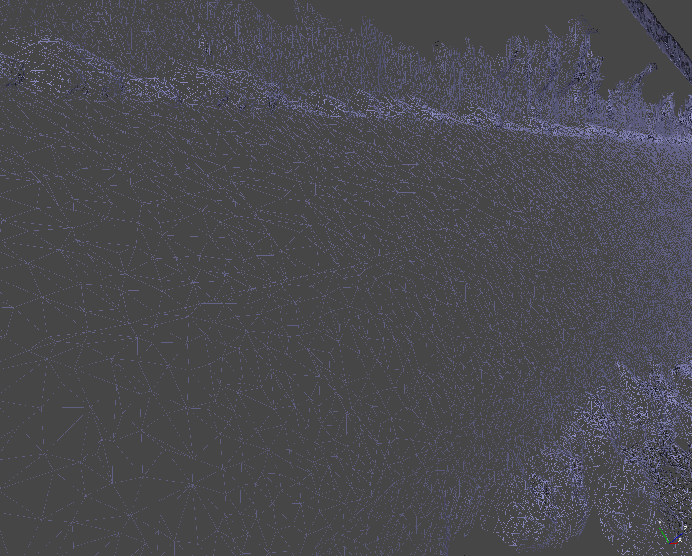
Unlike traditional methods of measuring objects, photogrammetry uses a series of overlapping photos to create a highly detailed 3D representation of an object. This technique is particularly well suited for obtaining accurate measurements of textures, making it an ideal choice for creating high-quality 3D assets.
The below image is an example of a textured photogrammetry mesh:

In addition to its accuracy, photogrammetry also offers a number of other benefits, such as the ability to create colorized models and the ability to measure distances and produce true-to-life PBR maps such as specular, gloss, roughness, and albedo. It is no wonder that photogrammetry is becoming the preferred method for obtaining information about physical objects.
The key to photogrammetry is in the measurement of the features of an object. By using a camera to take several pictures of an object from different angles, it is possible to map out all of its features and create a 3D model of it. This process is relatively fast and can be used to create models of objects that are too large or too small to be scanned using traditional methods.

With traditional scanning methods, it can take days or even weeks to scan a large object. Using photogrammetry, the same object can be scanned in a matter of hours or minutes. In addition, photogrammetry can be more accurate than traditional methods, making it ideal for creating detailed models of small objects. You can also create topographic maps and orthographic projections using photogrammetry software.
Sim racing is a growing sport that simulates real-world racing. One of the challenges of sim racing is creating accurate 3D models of tracks and roads.
While there are various ways to create these models, photogrammetry is the best method. This can be done from aerial images or terrestrial images taken with any high-resolution camera.

Close-range photogrammetry produces more detail than other methods, such as laser scanning, and it can be used to create both physical and visual 3D models. As a result, photogrammetry is the best way to create 3D road models for sim racing, resulting in a more realistic feeling in your steering wheel and motion seat.
For things that are difficult to access, such as buildings or mountains, the process involves taking aerial imagery of the object from different angles and then using photogrammetry software like Metashape or Reality Capture to determine each camera location and create a point cloud which then becomes a 3D model.
Aerial photogrammetry can be used for a variety of purposes, such as elevation maps or analyzing archaeological sites. The advantage of aerial photogrammetry over terrestrial photogrammetry is that it can provide a more complete view of an object since aerial cameras can capture imagery from all sides. As a result, aerial photogrammetry is an essential tool for those who need to create topographic maps or study anything that is difficult to reach.
Photogrammetry is a technology that is excellent for producing clean and accurate collision meshes for physics calculations. This technology is now being used more and more in the world of racing simulations. The reason for this is simple: the ground is never perfectly flat. There are always bumps, ripples, and other irregularities that we want to experience as tactile feedback from our steering wheel in a race.
By using photogrammetry to create a collision mesh, sim racers can be sure that the road details are accurately represented. This can be a critical factor in ensuring that the simulation is realistic. In addition, photogrammetry software can also be used to create other objects such as buildings and trees.
This technology is becoming increasingly important in the world of simulation, and it is likely that it will only become more prevalent in the years to come.
In the world of sim racing, image quality is everything. That's why photogrammetry software is such an important tool for creating high-quality normal maps.
Normal maps allow for a greater level of visual detail in a game engine without sacrificing performance. They are textures that are used to simulate the appearance of high-resolution geometry on low-poly meshes.
By using photogrammetry software to process images into high-poly models, it is possible to develop normal maps that are incredibly detailed and accurate. This helps developers ensure that the assets are accurate representations of real-world objects, creating a more immersive and realistic sim racing experience.
Photogrammetry was originally developed for use in surveying and mapping, but it has since been adapted for use in a variety of fields, including video game development.
In the past, creating detailed and accurate 3D models of racetracks for sim racing games was a time-consuming and expensive process. However, thanks to the advent of photogrammetry, it is now possible to quickly and easily produce high-quality 3D assets.
This cost-effective technique has the potential to revolutionize the way in which sim racing games and mods are made. Most people already own the necessary hardware: a camera and a computer. Compared to a LiDAR scanner, photogrammetry software is a fraction of the cost, and free options exist such as Meshroom and PhotoCatch.

If you need to speed through a 3D scan, close-range techniques and aerial photography are both fast and high-quality methods of capturing real-world roads for sim racing. Close-range photogrammetry produces a very accurate representation of the ground which adds a lot of detail to the force feedback generated by your steering wheel.
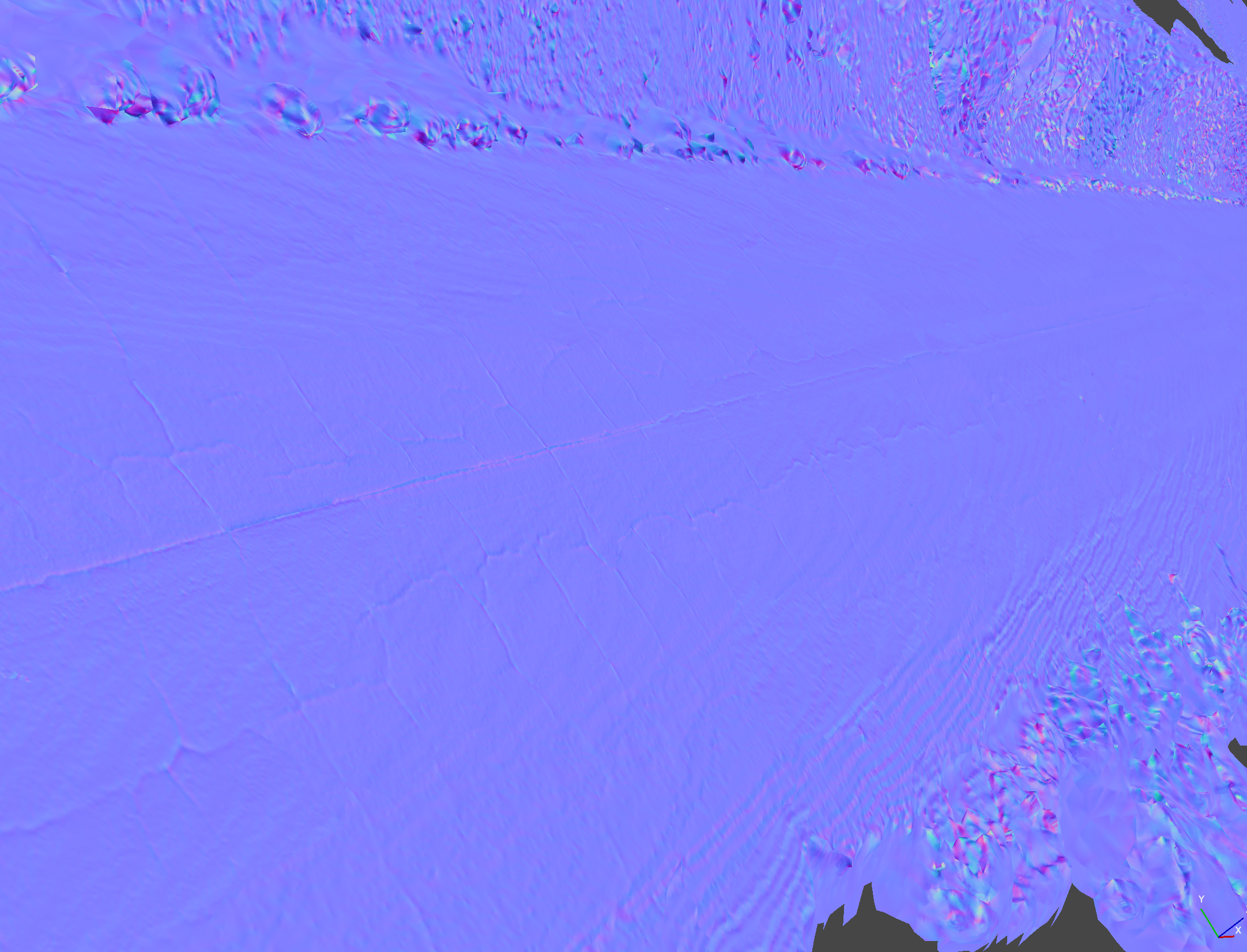
For example, the mesh below was captured in less than 10 minutes using only an iPhone 13 Pro.
Aerial photography is another fast and high-quality method of capturing roads and the terrain surrounding them. By using a drone or an airplane, we can take thousands of photos from above. This data can then be used to create a digital elevation model or a textured 3D mesh that can be used for sim racing.
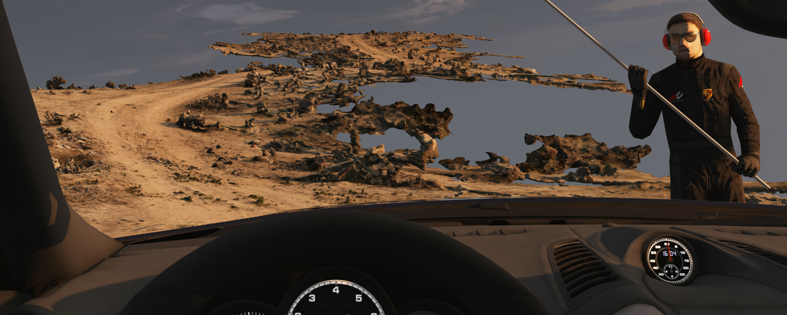
The use of photogrammetry is a welcome development in the realm of driving physics simulations. By making use of real-world measurements and other data points, photogrammetry can produce ultra-realistic results.
For instance, the image below shows the collision mesh after having its polygon count reduced dramatically, and yet it still retains important detail like the rumble strip in the center of the road.

This is a far cry from the early days of driving simulations, when the focus was more on producing a fun experience rather than creating an accurate representation of vehicle physics and other phenomena.
Photogrammetry has an advantage over laser scans because photos capture more data points resulting in sub-millimeter accuracy even from a long distance. LiDAR scanners costing over $80,000 can only produce laser scans with 6mm accuracy at a distance of 10m.
The use of photogrammetry allows for a much more immersive and realistic experience that better educates drivers on the consequences of their actions. In this way, photogrammetry has the potential to save lives by providing a more accurate representation of the risks inherent in driving.
For example, many maps available for racing simulators are computer generated, so they end up being overly flat and lifeless compared to a real road or track. By using photogrammetry, the actual road details such as bumps, cracks, and camber changes are perfectly represented in a simulator. This makes the experience more fun and challenging, as well as a better educational tool.
Photogrammetry has quickly become an industry standard for creating high-quality 3D assets. The data collected from photos can be used to form incredibly detailed meshes and normal maps, which are essential for low-poly meshes. In addition, photogrammetry is a cost-effective and fast way to create high-quality 3D assets. This makes it the perfect technology to satisfy racing sim enthusiasts who want the most realistic driving experience possible.
So far, we’ve only been able to scratch the surface of what’s possible with photogrammetry in sim racing. At Real Sim Roads, we believe that the future of sim racing lies in the use of photogrammetry, and we are excited to set the example for what is possible while developing a technique that anyone can learn and use to recreate their favorite roads in Assetto Corsa.
If you haven’t already tried it out, download Alpine Meadows now and experience the most realistic road in sim racing!
.jpg)
Looking for a breathtaking driving experience? Look no further than Alpine Meadows Rd. This stunning alpine landscape is home to winding roads and fast corners that will test even the most experienced drivers. Whether you're looking for a challenge or to take in the scenery, Alpine Meadows is worth downloading!
%20(Large).jpg)
.jpg)
%20(Large).jpg)